Tryon River Trail
Gallery

Quick Facts
| Difficulty | easy |
| Trail Type | mixed |
| Distance | 3.8 km |
| Estimated Time | 1 hr 15 mins |
| Surface Type | crushed rock, grass |
| Elevation Change | 16 meters |
| Features | river, marsh, fields |
| Trail Markers | mowed |
| Scenery Rating | beautiful |
| Maintenance Rating | well maintained |
| Cell Reception | strong |
| Dog Friendly | yes |
| Fees | by donation |
Store

Description
The trail starts by going through a small stretch of forest between roads. In this section you will find several benches and interpretive signs that tell about the history of Tryon. You may want to visit the Tryon Museum next to trail to learn more.
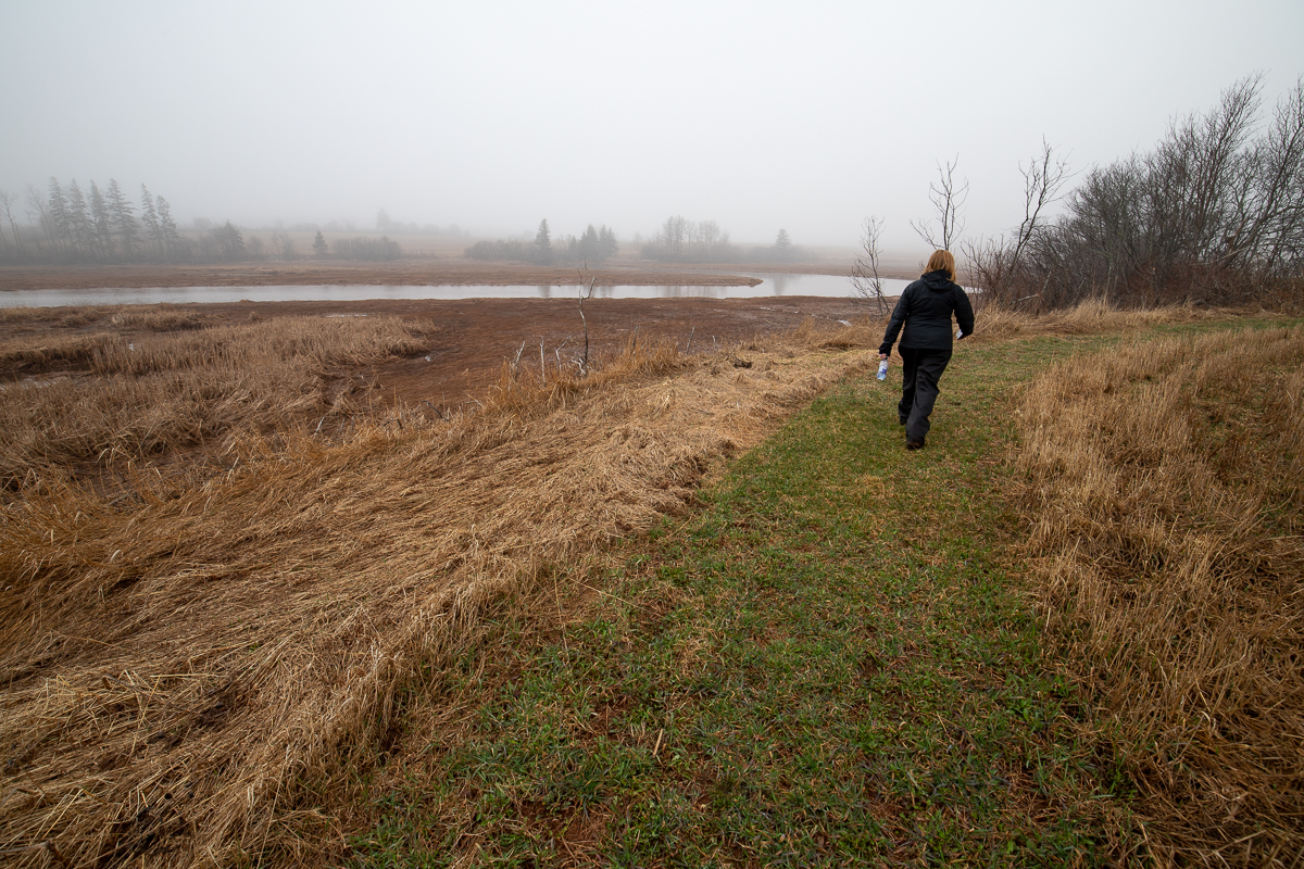
After crossing the road the trail travels along the edge of fields next to wetlands that surround Tryon River. From the long grasses and cattails you are sure to hear the call of a Red-winged blackbird among other birds. In the river you may see ducks and other waterfowl. The trail soon loops around a large field that is owned by the Island Nature Trust.
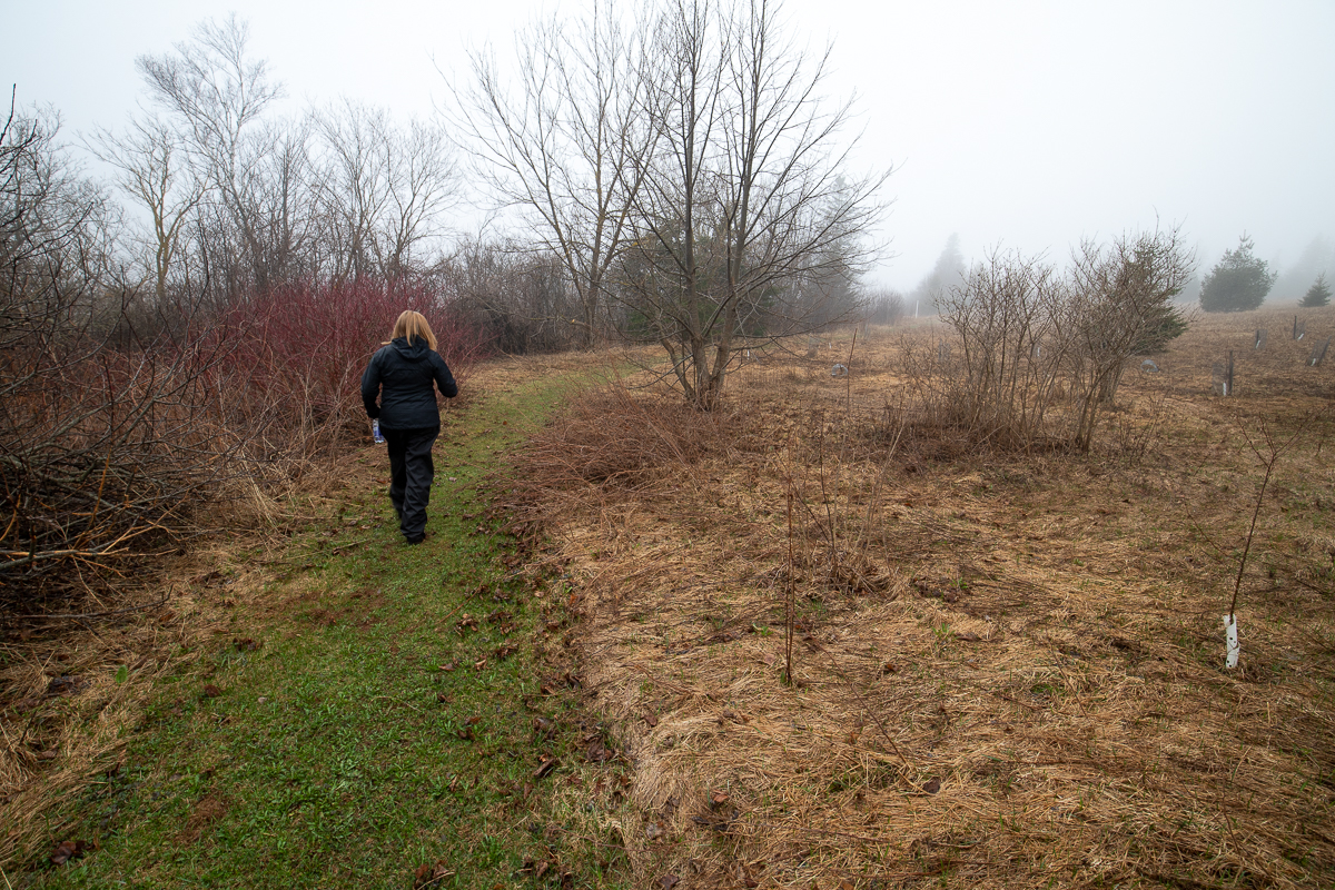
At the back corner of the field there is an extension trail. The trail travels through a strip of trees and then continues to follow the edge of the field next to the river. At this point the trail comes closest to the river as it meanders back and forth across the floodplain.
The trail then goes through a small patch of trees and emerges along another field. The trail once again comes close to the river. The trail then loops around and heads back towards the road, continuing to follow along the strip of trees between the field and the floodplain. When you reach the road you can either return the way you came or walk back on the road. The first part of the road is on the highway but soon you will have to cross over to a short dead end road that you crossed at the start of the trail.
Map

Directions
From Borden-Carleton travel on highway 1 towards Charlottotown. After 14 kilometres turn right at the the exit to Augustine Cove. After 350 metres you will see the Tryon Museum on the left. The trail starts on the right just past the museum. You can part along the road just past the trail head.

Another option for parking is to continue to the South Shore United Church. Continue around the turn and you will see the church on your left. A road along the edge of the graveyard will take you to the trail head.
From the Sign
PLACE NAME - TRYON
It is believed the Mi'kmaq hunted and fished in the area and their name for Tryon was Tulesipk - (meaning unknown).
In the mid 1700s the French Acadians settled here, clearing forests and farming the salt marshes. They named the river, Rivière des Blonds.
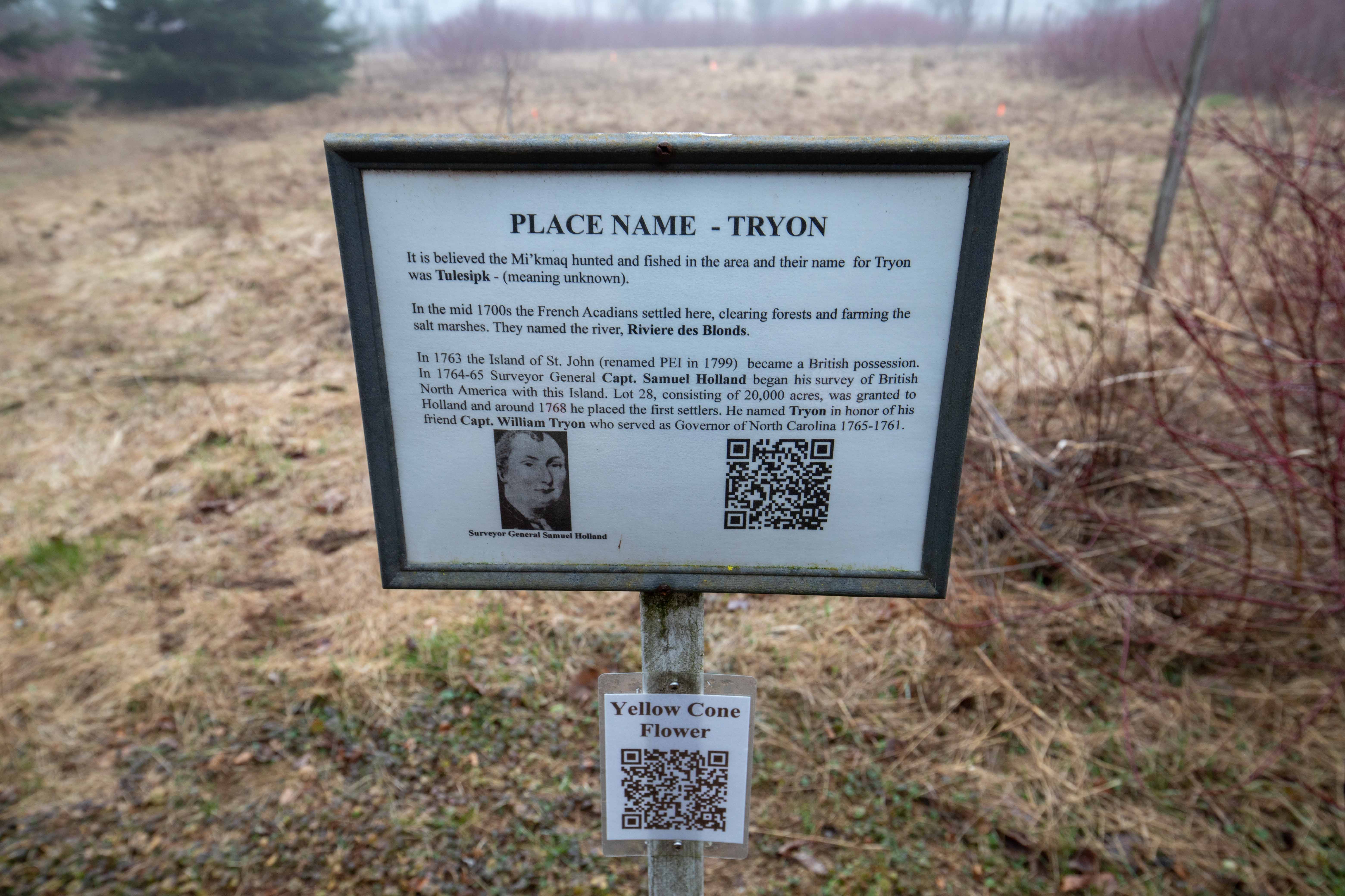
In 1763 the Island of St. John (renamed PEI in 1799) became a British possession. In 1764-65 Surveyor General Capt. Samuel Holland began his survey of British North America with this Island. Lot 28, consisting of 20,000 acres, was granted to Holland and around 1768 he placed the first settlers. He named Tryon in honor of his friend Capt. William Tryon who served as Governor of North Carolina 1765-1761.
From the Sign
THE SALTWATER MARSH
The saltwater marsh is formed from sediment deposited by the continual rising and falling tides. The daily tides, the salinity of the floodwaters, and the slope of the marsh influence the zones of vegetation and animal life on the marsh. The first zone, the "Pioneer Zone" consists of salt-tolerant plants such as cordgrass. The second zone, called the "Salt Meadow", extends to the mean high water mark and is dominated by a fine low grass that was cut as "Marsh Hay" by the early settlers. The third zone, the "High Salt Marsh", is flooded only by the highest spring and fall tides as well as storm tides. Typical vegetation here is the Wild Rose.

An interesting plant called the Common Reed, visible about half-way out on the marsh, is usually found in areas on PEI where the Acadians had settled. Other evidence of early settlers is the ditches that were dug to drain the marsh and the dykes used to control the flow of water. The pools on the marsh are either natural or a result of farmers digging the fertile marsh mud.
For your safety, and because of the fragile nature of the marsh eco-system, please do not proceed onto the marsh beyond this point.
From the Sign
FIELD
This field belongs to the Island Nature Trust, which is gradually being reforested with native shrubs and trees.
The field is also one of several locations along the Tryon River where Acadian buildings were located, as identified on Surveyor General Samuel Holland's map of 1764-65. Easy access for farming the marshlands, proximity of fresh-water springs, and a Southern exposure probably contributed to this choice for homesteading.
Evidence of Acadian presence is confirmed by the presence of the Common Reed, which grows on the marsh, and is believed to be used by them for thatching.
Before their deportation in 1758, the Acadians cleared approximately 450 acres of forests in Tryon. The tradition of farming the marshes was continued by the English settlers, starting about 1768.
Trail Last Hiked: April 22, 2019.
Page Last Updated: April 24, 2019.